
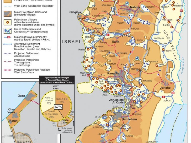
Stop the Wall released the most detailed map as of today of Trump’s Peace to Prosperity plan, including a commentary. It shows the real impact of this ‘masterplan’ – vision fully designed on the basis of Israel’s pre-existing annexation plans. With the possible annexation of 33% of the West Bank, over 75 Palestinian villages, Bedouin […]
Maps
Stop Arming Israel: Mapping Israeli Suppliers
More than 100 companies supplying military and security equipment to Israel have bases in the UK. The map includes UK companies that sell arms or provide security services to Israel, UK sites of international companies which arm Israel and UK sites of Israeli arms companies. Find out more about the suppliers on your doorstep at caat.org.uk/map/israel To view a map […]
Interactive Wall map by al Haq
In occasion of the 10th anniversary of the decision of the International Court of Justice on the legal consequences of Israel’s construction of the Apartheid Wall, al Haq has developed a new interactive map on the Wall. To access the map, click here. When completed, only 13% of the Wall will be built on […]
Interactive map on communities faced with displacement
UN OCHA in the occupied Palestinian territories have developed the 'Vulnerability Profile Project (VPP)'. According to OCHA it is 'a tool designed to visualize/map humanitarian indicators in an interactive-web based platform'. In other words, it organizes UN OCHA's information on (threats of) demolitions, land confiscation, denial of access to water, denial of social services, such […]
UN OCHA – Bedouin at risk of displacement
See map here
Segregated Roads: The Infrastructure of Apartheid
Cars with Palestinian license plates are not allowed on Israeli roads, regardless of the identification held by the driver. Even on Palestinian roads, cars with Palestinian plates have restricted access, face endless delays at checkpoints and are subject to regular road blocks. Cars with Israeli plates experience none of these difficulties. The infographic ‘Segregated Roads’ […]
Jerusalem Train Map
Since Israel's establishment in 1948, its occupation of Jerusalem in June 1967, and subsequent annexation of the city in 1980, it has implemented policies that have shrunk the size of Occupied Jerusalem's Palestinian population as well as its Arab and Islamic heritage. The ongoing light rail project is just the latest in this steady entrenchment […]
Judaizing Jerusalem – the Ethnic Cleansing of the Palestinian Capital
The Apartheid Wall is almost completed in Jerusalem, snaking around Palestinian communities and shutting them out of the city. Settlements expand and new colonies emerge on the Palestinian lands left isolated behind the Wall. A railway project seeks to integrate the illegal settlements into the city. In the Palestinian capital – like the rest of […]
The New Israeli “Disengagement Plan” Map
The New "Disengagement Plan" Map shows the completed sections of the Apartheid Wall in the northern West Bank (in black) and the remaining planned sections in blue. The Occupation’s first phase of the Wall in the northern West Bank, from Zububa village in the Jenin district to Masha village in the south of the Qalqiliya […]